
October 24, 2022
Field Testing for Walking Network Plans
The Queensland Department of Transport and Main Roads (TMR) aims to be a leader in the provision of dignified, accessible and inclusive transport products, services, information and infrastructure. (Accessibility and Inclusion Strategy)
TMR’s Queensland Walking Strategy 2019-2029 identifies walking as playing a critical role as part of a single integrated transport system accessible to everyone.
Walking Network Plans and Priority Works Programs
TMR works with local governments to create walking network plans (WNPs) that show preferred walking routes in a 1-2km catchment around selected destinations. Each WNP then feeds into a Priority Works Program of improvements needed to create a quality walking environment.
“The fieldwork and analysis provided by Briometrix showed how challenging it can be to use a wheelchair when footpaths are broken or don’t exist, and how vital an accessible walking network is for everyone.“
Andrew Ross
Pedestrian Planner, QLD Transport & Main Roads
Briometrix Field Assessment sites
Briometrix provided field assessments of Draft Walking Network Plans (WNP) within 2kms of three locations for TMR:
- Broadbeach South Light Rail Station (with City of Gold Coast)
- Sunshine Coast University Hospital (with Sunshine Coast Council)
- Warrina Shopping Precinct (with Townsville City Council)
For each project we worked with the appointed planning consultants and the City Council under the guidance of TMR’s Walking and Cycling team. Our role was to test the recommended Primary/Secondary routes for viability, accessibility and connectivity.

Broadbeach South Light Rail Station, City of Gold Coast
Broadbeach Overview
Urban environment: High density Modern Highrise apartments beachside, with 1960s-70s canal developments west of the Gold Coast Highway.
Focal point: Broadbeach South Light Rail station, created on Gold Coast Highway for 2018 Commonwealth Games
Footpath/walking environment: Major roads North-South and East-West with intermittent footpaths. Virtually no footpaths in the canal suburbs. Good effort Rating on most existing footpaths.
Connectivity Challenges: no footpaths in canal areas, north-south canal west of Gold Coast Highway divides coastal strip (recreation paths) from the residential areas with limited opportunities to cross the canal. Minor areas of missing footpaths, narrow footpaths with power-pole obstructions.
Public Transport: Light Rail and Transit Buses
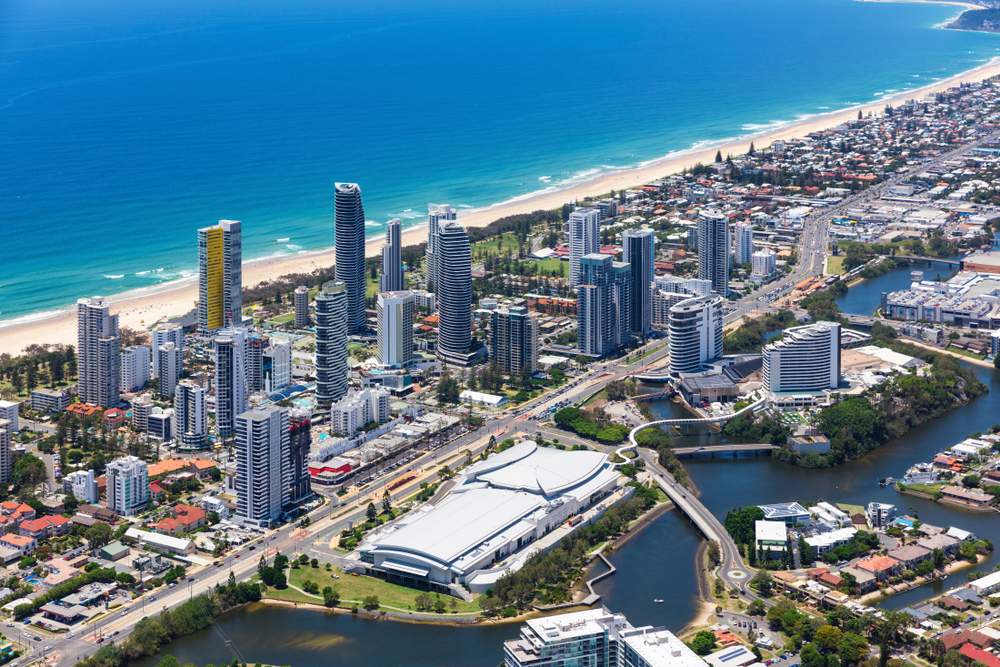
BROADBEACH AERIAL VIEW from North-West
Convention Centre, Casino and shopping mall in foreground,
Broadbeach South Light Rail Station middle-right [Click for larger view]

Wheelchair Pilot Bevan Kearslay
capturing platform data on Broadbeach South Light Rail Station
")
Broadbeach South Light Rail Stations, 2016
Image Simon_sees from Australia, CC by 2.0 Wikipedia
.jpg)
Briometrix surveyed 35km of footpaths, measuring slope, crossfall, surface type, surface condition, effort rating, shade, bus stops and public toilets.
Sunshine Coast University Hospital, Sunshine Coast Council
University Hospital Overview
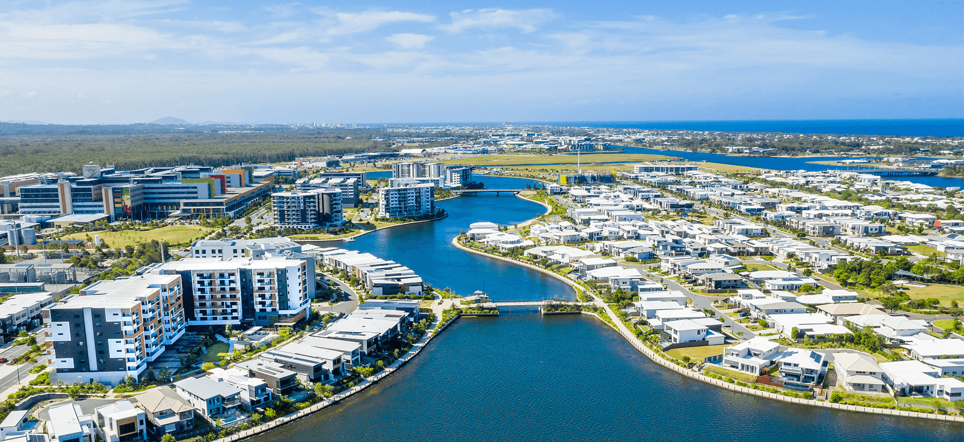
Urban Environment: Older developments along coastal strip with medium density multiplex housing in Stockland’s Kawana Waters development from about 2008. New hospital and retail strip on Kawana Way running North-South.
Focal point: Sunshine Coast University Hospital (opened in 2016 doubling in size to 750 beds in 2021)
Footpath/Walking Environment: Very good footpath environment, mainly concrete with good vertical geometry. Stick-on TGSI tiles are problematic on Kerb Ramps. Good Effort Ratings overall.
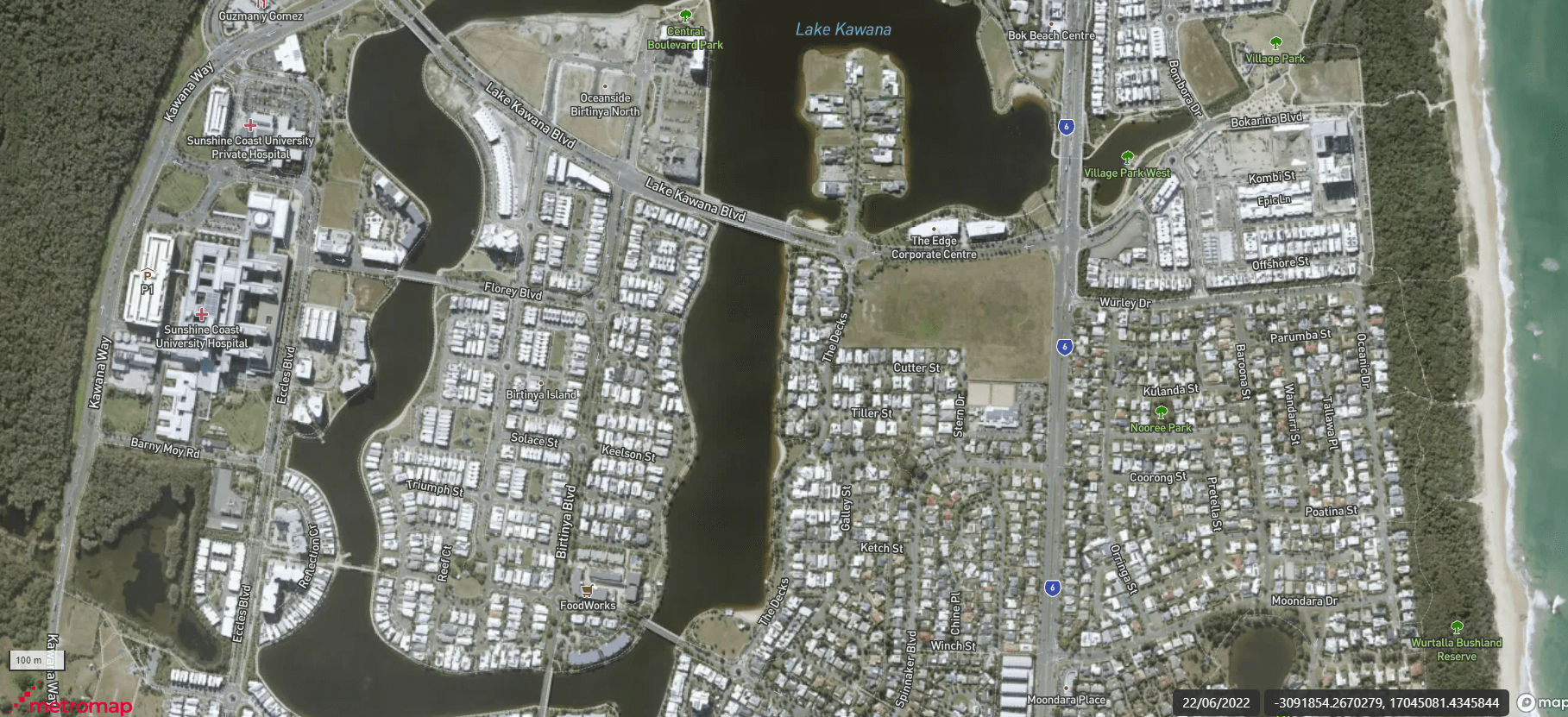
Connectivity Challenges: Lake Kawana runs north-south dividing area into two, with only two bridges to cross the lake, limiting opportunities for variety in walking paths. Kawana Way as a north-south corridor, traffic acts as barrier to access bushland walking trails
Public Transport: Transit Buses, large areas of new housing with no bus services.
Above: Video by LendLease (2016)
Below:Urban development by Stockland. University Hospital is middle left, on the upper right is the Sunshine Coast Stadium site, nominated as a venue for the 2032 Brisbane Olympics.

Wheelchair Pilot Jason Jones
capturing footpath data on the western side of Lake Kawana
Testing or “ground-truthing” this proposed Walking Network posed fewer logistical challenges than either Broadbeach or Warrina, because much of the area within 2km of the University Hospital was developed as medium density housing in the last 5-6 years. It is well-served by footpaths in good condition, giving multiple route options. The older area of low density bungalows to the East of the lake had many fewer pathways and choices. Some sub-routes could not be mapped because there were no footpaths at all (refer to the Aerial Imagery below).
BELOW: Aerial Imagery copyright Metromap by Aerometrex, flown mid-2022
Briometrix surveyed 27km of footpaths, measuring slope, crossfall, surface type, surface condition, effort rating, shade, wayfinding signage, 20 bus stops, 84 accessible parking bays and 11 public toilets.
Warrina Shopping Precinct, Townsville City Council
Warrina Overview
Urban Environment: Mixture of light industrial and current/former public housing. RAAF Base Townsville is a significant local presence. A lower socio-economic demographic profile compared to the Broadbeach and Sunshine Coast projects.
Footpath/Walking Environment: Compared to the other two projects, Warrina has very few footpaths to choose from, and those that exist have significant discontinuities and traffic hazards.
Connectivity Challenges: No fully continuous footpaths connecting directly north-south or east-west. Very significant discontinuities created by Dalrymple Rd which has no footpaths, and Woolcock St which has large lengths of missing footpaths. Of the routes recommended for future walking paths, more than 50% had no available footpaths on either side of the street.
Public Transport: Transit Buses, e-scooters very popular. Bus services available on north 30% and south 30%, while the Middle 30% has no bus services at all and no services cross between the north and south sectors.

Warrina Shopping Precinct in foreground, with WNP area, looking East-North-East

Wheelchair Pilot Jason Jones
demonstrates the challenge of reaching the traffic light button at this traffic island

Screen capture from Briometrix Photo Viewer, showing TGSI issues at an intersection.
As for Sunshine Coast, these issues relate to the use of glued TGSI tiles on kerb ramps in a tropical climate
Briometrix surveyed 29km of footpaths, measuring slope, crossfall, surface type, surface condition, effort rating, wayfinding signage, bus stops and public toilets. Because of the number of streets with no footpaths, we also ran a vehicle-based geocoded video review of approximately 30km of extra streets to cover the Primary route options so the team could review these remotely.
Some thoughts for the community
The challenges
LOCAL GOVERNMENT: As owners of the footpath network, Local Government asset managers struggle with the ongoing maintenance cost. If maintenance and hazard reduction has not been continuous, the cost to repair or reinstate pathsways to “fit for purpose” state can be high, althought relatively modest compared to the costs of road building and repairs.
COMMUNITY HEALTH & WELFARE: We urgently need solutions because we now recognise the benefits enabled by footpaths for active travel, exercise and tourism: bringing better economic, health and social outcomes.
COMMUNITY CONFIDENCE: Studies show that pedestrians (especially those with limited mobility) stop using footpaths because a past bad experience has left them unsure of where they can go and how safe they will be. While engineers advocate spending programs to lift footpath quality, there is a real need to enable community confidence through greater awareness of pedestrian routes.
Solutions
QLD TMR Pilot Projects: In its previous pilot projects, QLD TMR engaged Briometrix to gain a new perspective on walkability – by viewing the footpath network through the eyes and experience of its most sensitive user – the wheelchair user.
Briometrix maintains a focus on data capture that is relevant to council planning & maintenance needs and can help to reveal viable routes for pedestrian users today, without footpath remediation or replacement.
Briometrix published Mobility Maps to provide people with confidence to go out and use the footpath network, hence connecting to, and increasing public transport ridership., enabling economic growth and community wellbeing.
Correcting the “DISABILITY Afterthought“: Far too often the needs of those with mobility issues are assessed only as a final step. Their views are brought in to ‘test and tweak’ the final offering. This situation needs to be reversed, with those most reliant upon good footpaths being among the first to be consulted, to establish the ground rules and mandatory specification of any proposed Walking Network. By working with the community we can create greater trust and confidence in the project outcomes – “done with us” – rather than presented as “done for us” on project completion.
This program of WNPs and Programs of Work by TMR has the opportunity to change that process, to ensure that mobility, accessibility and inclusion is part of the base specification and planning process from its beginning.
Briometrix is helping to create a ‘ground truth’ of the footpath network from the perspective of those with mobility needs, and this type of assessment should be included as a formal part of all future transport planning across the country. Ideally we believe this is best done firstly by involving people with lived experience in the initial walking planning specification for the external consulting engineers or Council traffic planners, then by having experienced wheelchair users engaged in the WNP Testing and post-test assessment or data analysis process.
Outcomes
DATA & Briefings: We provided data that helps TMR, Consultants and Councils to determine the key areas / blockages that ‘stop a journey’ or ‘discourage people due to poor experience’. We have communicated these findings with the planning teams and also at community consultation workshops.
EFFORT, CONNECTIVITY & RISK: We provided data and maps that incorporate and illustrate the key issues of a journey to or from each of the three focal locations – effort, connectivity and risk
MOBILITY MAPS: Briometrix has made its colour-coded Effort based mobility maps available to Councils thereby “making accessibility visible”. In the cases of Townsville and Sunshine Coast, these projects have been used to extend the coverage of their existing mobility maps in those cities.
